GPS (12:00): 78°14.2’N / 015°36.6’E; Weather: 5°C, overcast; Sea conditions: Slight
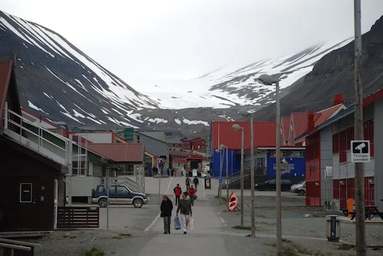
Arrival in Longyearbyen came after a long northern arc via Tromsø—punctuated by an unusual disembarkation and re-boarding—before touching down close to midday. One of the northernmost airports on Earth, the approach revealed a stark, stripped-back landscape that felt more geological than human.
The flight was full, and it quickly became apparent that many fellow passengers were bound for the same Arctic voyage. Luggage was handed over to the expedition team, and we were released briefly into the town. Longyearbyen revealed itself quickly: a short stretch of road lined with a handful of hotels, shops, restaurants, and a museum—functional, compact, and unmistakably frontier.
What lingered was the air: sharp, clean, almost startling in its freshness. The silence was equally pronounced. Though the sky remained overcast, conditions felt calm and steady. Well-equipped after a final gear stop in Oslo, I wandered briefly before making my way to the port.
By afternoon, we boarded Ortelius - our home for the next ten days. That night passed smoothly, the ship steady in gentle seas. Sleep came under full daylight, the sun circling endlessly above the horizon. Midnight sun is disorienting at first—time loosens its grip—but this was only the beginning of recalibration.
GPS (12:00): 78°50.1’N / 011°51.0’E; Weather: 6°C, overcast; Sea conditions: Calm
Morning found us anchored in Engelskbukta, a sheltered bay on the west coast of Oscar II Land. Sharp, snow-laced peaks rose around us, angular and austere. Zodiacs ferried us ashore onto a pale sandy beach along the north shore.
The group divided—some ascending to a moraine overlooking the bay, others moving toward a glacier viewpoint. This rhythm would define our days: multiple routes, varied paces, one shared landscape.
Despite the scale of the mountains, life here remained close to the ground. Willows hugged the earth. Moss campion and purple saxifrage added rare colour. In the lagoon, a bearded seal surfaced, lingering long enough to assess us before slipping away.
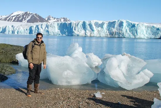
After lunch, Ortelius entered Kongsfjorden and docked at Ny-Ålesund (78°55′N / 11°56′E), among the northernmost permanent settlements in the world. Research stations from numerous nations dotted the tundra. While some visited the Chinese Yellow River Station, I walked to the Indian station—quiet and unoccupied.
There were museums to browse, birds to observe, and a visit to the world’s northernmost post office—small rituals of civilisation at the edge of the map. Later, a ship cruise past the immense face of Lillehöökbreen reinforced the scale of Arctic ice.
Here, perspective shifts easily; human presence feels brief and inconsequential.

GPS (12:00): 79°40.1’N / 013°07.8’E; Weather: 6°C, slightly overcast; Sea conditions: Calm, windy
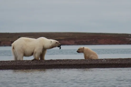
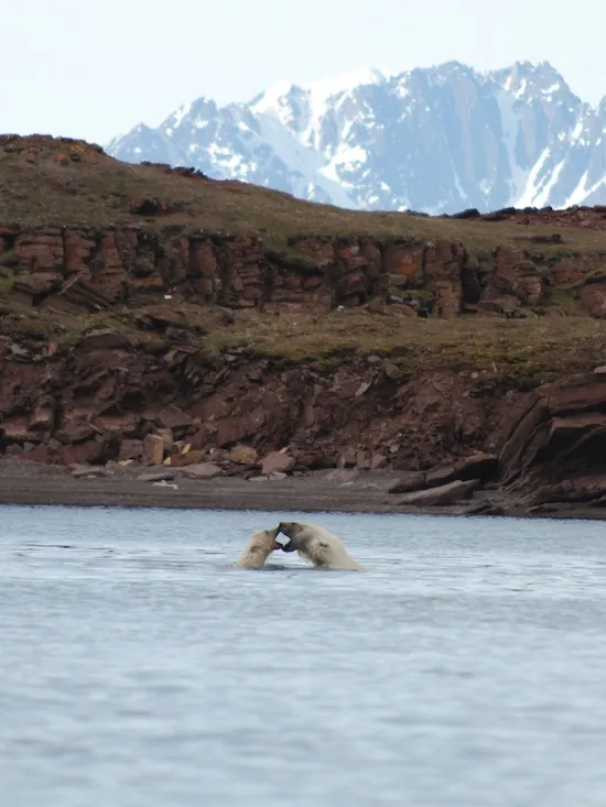
We awoke to excellent conditions near Andøyane—the Duck Islands. Plans shifted quickly following reports of polar bears: solitary individuals, and a mother with cub.
Prepared and briefed, I boarded the first Zodiac alongside expedition leader Rinie. As we approached the islands, kittiwakes crowded the water and perched atop icebergs. Then we saw them.
The polar bear mother and cub were already in motion—swimming between islands, climbing out onto rock, returning to the water. We approached slowly, allowing the bears to dictate distance. After brief alertness, they settled. The cub played freely. The mother scavenged eider duck nests for eggs. We observed quietly, conscious of the privilege and responsibility of proximity.
Later, we landed at Texas Bar, a small hut built in 1927 by Hilmar Nøis. Weathered but intact, it bore signs of recent disturbance—possibly by a bear. A long hike followed, with distant sightings of another team tracking a separate bear.
The day closed with a slow cruise along Monacobreen glacier. Light softened across the ice, and the scale of the glacier seemed to grow as we drifted past it.
GPS (12:00): 80°23.0’N / 018°90.7’E; Weather: 2°C, fog; Sea conditions: Ice, wind
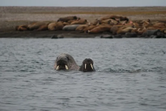
Fog settled in overnight. Anchored near Lågøya, we launched Zodiacs toward a known walrus haul-out. The ride was rough, water choppy near shore.
Approaching on foot, we stopped roughly 50 metres from the animals. In water, walruses move with surprising ease; on land, they are cumbersome, vocal, and perpetually jostling for position. Grumbles and bellows echoed as individuals hauled out, paused, then settled again.
Back aboard, Ortelius pushed north into the pack ice. Wind and fog reduced visibility, and temperatures felt sharp for those newly arrived from warmer climates. The ship’s ice-strengthened hull moved steadily, breaking through first-year ice with ease.
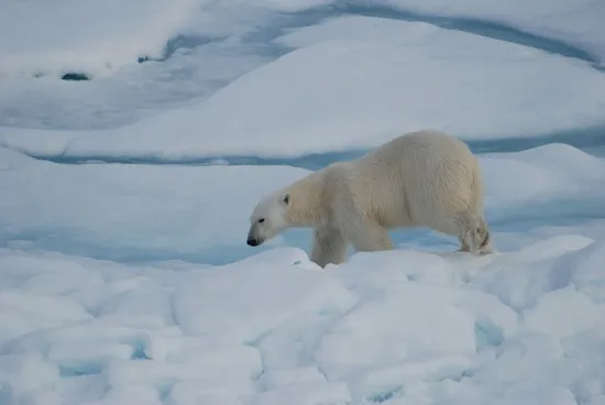
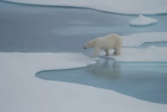
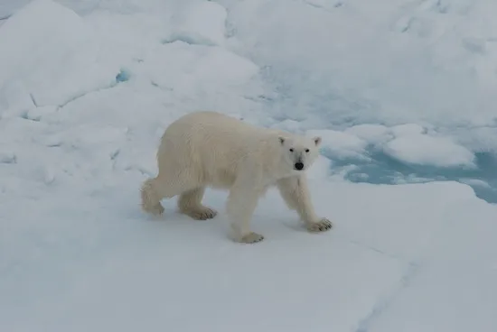
That evening, a large male polar bear appeared on the ice—distant, ghostlike in the fog. He vanished as quickly as he emerged. Many stayed awake long after, scanning the horizon.
GPS (12:00): 79°39.4’N / 020°17.5’E; Weather: -1°C, overcast/fog; Sea conditions: Ice, wind
We spent the day tracing the ice edge. Fog persisted, flattening light and compressing distance. Seals rested on floes. Polar bears appeared briefly, then dissolved back into the white.
One encounter brought a bear close alongside the ship. Drawn by curiosity, it approached before suddenly pivoting away, splashing through melt pools and disappearing into the ice field.
Between sightings, lectures filled the day—on seabirds, seals, and polar bears—context layered atop experience. We reached our northernmost point at 81°14.3’N, marking the moment with hot chocolate on deck, surrounded by ice and silence.
GPS (12:00): 79°57.4’N / 018°05.4’E; Weather: 0°C, overcast; Sea conditions: Slight, windy
Turning south, we anchored near Russøya and Krosøya. The land here was sparse—purple saxifrage, scurvy grass, scattered eider ducks. Underfoot, rocks fractured easily, shaped by countless freeze-thaw cycles into brittle patterns.
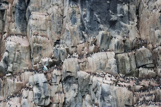
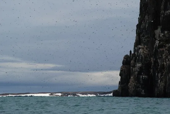
The afternoon delivered scale. Zodiac cruising along Alkefjellet revealed towering cliffs alive with sound. Nearly 100,000 breeding pairs of guillemots, auks, and kittiwakes filled the air. Below, an Arctic fox moved carefully along the slope, searching for opportunity beneath the chaos above.
GPS (12:00): 78°14.0’N / 021°22.5’E; Weather: 4°C, cloudy; Sea conditions: Calm, windy
Gray skies persisted as we landed on Barentsøya. A long hike up gentle slopes worked up both warmth and appetite. On the descent, we encountered a young female reindeer—unbothered, briefly curious.
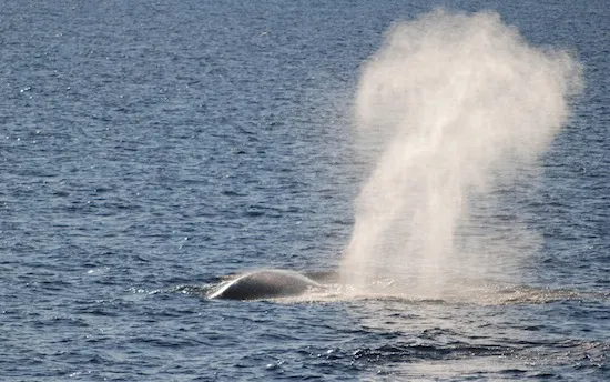
The afternoon unfolded onboard with cultural activities hosted by the Chinese guests. Later, clearing skies revealed fin whales. Blows rose cleanly against the horizon as a pod surfaced repeatedly before moving on.

GPS (12:00): 77°00.1’N / 015°38.9’E; Weather: 4°C, clear; Sea conditions: Calm, windy
Clear conditions accompanied our anchorage at Hansbreen glacier. Groups divided between glacier hikes and a visit to a Little Auk colony. On the shorter hike, a section of glacier calved without warning—ice breaking free with a sharp, percussive force.
Later, Zodiac cruising among the icebergs of Burgerbukta brought a different soundscape: the crackle and pop of ancient air bubbles escaping the ice.
Evening brought an Arctic barbecue on deck—wind, laughter, and a brief suspension of realty- in spectacular show of patriotism, one of the expedition crew was out freezing (or not?) in his union jack underpants!

GPS (12:00): 78°26.1’N / 011°55.0’E; Weather: 5°C, clear; Sea conditions: Calm, windy
Our final morning landing at Poolepynten offered close views of walruses resting on the beach. Offshore, kittiwakes plunged repeatedly into the water in coordinated dives.
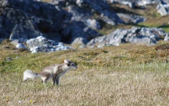
At Alkhornet, we followed reindeer tracks and then fox. While focused on one animal, others played quietly behind us—observing the observers. A fox den provided brief but memorable activity before the scene returned to stillness.
GPS (12:00): 78°14.2’N / 015°36.6’E
We departed at 02:00 under full daylight, to catch the early morning flights. Inside, the mood was subdued. Outside, the sun continued its endless circuit. Goodbyes were exchanged quietly as the expedition came to its close.
First-hand stories from the world’s most remote regions - real expedition experiences from Antarctica and the Arctic, told by those who have been there.
Connect with polar experts
